shopping_cart
Cart
Shoping Cart
0
€0.00
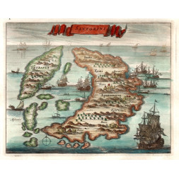
Aprutium Citra et Ultra - Hondius 1627
€220.00
No tax
Abruzzo
 Security policy
(edit with the Customer Reassurance module)
 Delivery policy
(edit with the Customer Reassurance module)
 Return policy
(edit with the Customer Reassurance module)
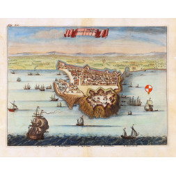
Title: "Aprutium Citra et Ultra"
Date: 1627
Author: J. Hondius
Publisher: Bonaventura / Elsevir. Leiden.
Technique: copper plate
Verso: latin text
Size:
Sheet 21,5 cm x 27,5 cm
Engraving 17,5 cm x 24,5 cm
Condition: restored tear to the upper right edge - overall good condition
Note: from "Nova et Accurata Italiae Hoderniae Descriptio (...)"
Comments (0)
No customer reviews for the moment.
16 other products in the same category:


- New
Thailand Indonesia Singapore Cambodia Malaysia Vietnam